Proven Product Reduces Capital Costs and Shortens Time to Revenue for Fiber Rollouts
DENVER, Sept. 28, 2011 – Ubisense and atesio announced today the North American release of the Ubisense FTTx Planning System. The product automates the strategic planning of fiber access networks and significantly reduces the time and capital investment required for service providers to deliver fiber connectivity to homes and businesses. The solution is in regular use at Deutsche Telekom, one of the largest telecom operators in the world with approximately 40 million access lines.
The Ubisense FTTx Planning System reduces the time it takes to analyze, plan and estimate a cost-optimized, structurally sound network design and configuration from several weeks to a few hours. The solution quickly analyzes multiple planning alternatives to find the scenario that balances revenue and capital costs across dozens of variables. It uses available infrastructure data to produce an optimized network plan that includes equipment and cable material quantities and cost estimates for various deployment scenarios such as greenfield and brownfield.
“We wanted to bring our customers a solution that would get them to market faster, with the best possible network configuration,” said Scott Casey, Ubisense Vice President of Telecom Solutions. “Planning a cost optimized fiber access network with manual methods is daunting – there are simply too many factors and alternatives to process efficiently. With our solution, network operators can quickly create plans based on their existing infrastructure and business requirements.”
Ubisense partnered with atesio on the development of the FTTx Planning System. The solution uses atesio’s powerful computation engine and high-end mathematical optimization algorithms to ensure designs minimize total network deployment costs. Planners quickly get a comprehensive view of the economic efficiency of various planning options, can adjust input parameters and rerun calculations as often as needed to arrive at the optimal network design.
The Ubisense FTTx Planning System integrates with Ubisense myWorld to allow planners to perform desk survey verification of the proposed network layouts against real world conditions using Google Maps API Premier and Street View for Google Maps. The product is also fully integrated with GE’s Smallworld Core Spatial Technology.
Ubisense will demonstrate the FTTx Planning System at the FTTH Expo in Orlando, September 28-30, 2011.
For more information visit http://www.ubisense.net/en/consulting/geo-solutions/ubisense-fttx-planning-system.html
About atesio
atesio turns state-of-the-art mathematical optimization technology into industrial solutions for the telecommunications industry. Leading fixed and mobile operators take strategic decisions (3G, LTE, NGN, FTTX) on the basis of custom-made techno-economic studies by atesio. They also master network optimization and configuration tasks (2G, 3G, SDH, MPLS) by means of atesio's award-winning and powerful network optimization software. atesio was founded in 2000 as a spin-off of a world-wide leading mathematical optimization research institute. For more information, visit: www.atesio.com.
(ends)

Ubisense provides location intelligence solutions that enable organizations to optimize their business processes. Discover and follow your valuable assets online and offline with Ubisense Smart Factory and Ubisense myWorld.
Wednesday, September 28, 2011
Photo: GIS team at the Smallworld User Conference
 |
| Ubisense's booth at the Smallworld User Conference |
Tuesday, September 27, 2011
Latest News: Ubisense acquires InMaps
Acquisition of US geospatial location solutions business
Ubisense Group plc (AIM: UBI, "Ubisense" "the Group"), the market-leading location solutions company, has acquired Integrated Mapping Services Inc (“InMaps”), a US-based company focused on delivering geospatial business solutions to electric and gas utilities, for $700,000 in cash.
InMaps' provides a suite of products, integrated with GPS and geospatial products such as GE Smallworld, to help utilities improve reliability and comply with industry regulations.
The acquisition of InMaps strengthens Ubisense’s offering in the electric and gas industries and solidifies the Group’s position as one of the world’s leading location solutions companies. InMaps will become part of the Group’s Geospatial division and will operate under the Ubisense name.
In the year to 31 December 2010, InMaps had revenues of over $1m.
Richard Green, Ubisense CEO, commented:
“The products that InMaps has developed for the gas industry are a perfect fit with our own offering and the direction we are taking our Geospatial business.
“System safety and reliability are increasingly complicated and critical issues for gas and electric utilities. With the acquisition of InMaps, we will now be able to deliver a comprehensive suite of geospatial business solutions which will help our customers meet these challenges with the best available technologies.”
About InMaps
Since 1996, InMaps has been creating geospatial business solutions for natural gas and electric utilities. The Company is an acknowledged expert in deploying, customizing, and managing Smallworld systems.
InMaps’s newest product, VeroTrack® Automated Survey Tracking (AST) automates record keeping for natural gas leak surveys. Developed in conjunction with the Gas Technology Institute, VeroTrack AST is a unique solution that integrates with multiple GIS platforms.
Monday, September 26, 2011
Photo: Location Driven Manufacturing Solutions
 |
To learn more visit: http://www.ubisense.net/en/ubisense-manufacturing-solution-suite.php
Tuesday, September 20, 2011
Ubisense in Action: Asssembly & Automative Expo

Ubisense in the News: Business Weekly
Honeymoon continues as Ubisense revenues soar 41%
 Cambridge location solutions company Ubisense posted a promising set of maiden results on London Stock Exchange with first-half revenues 41 per cent higher.
The UK Real Time Location systems business said H1 revenues were up from £8m to £11.3m year-on-year.
Operating profit for the six months to end-June held steady but the loss was halved to £0.1m. The company had net cash of £8.1m.
The company picked up several new and major orders in the period and also established a French subsidiary.
Chief executive Richard Green, just back from his honeymoon on Skye, is confident the market’s love affair with Ubisense will continue.
Looking at a growing order book, he predicted the momentum would be continued into the second half.
He said: “We have delivered a robust set of results, our first, as a listed company, with a strong increase in revenues, a substantial order book and growing opportunity pipeline.
“Admission to AIM marked an important landmark in the Group’s development. It has provided us with a strong platform to support the rapid growth of our business and to leverage existing customer relationships with global leaders such as Aston Martin, Atlas Copco, BMW, Deutsche Telekom and EADS.
“With good momentum in the business and a growing order book, we remain confident that this robust performance will continue in the second half of 2011.”
end
http://www.businessweekly.co.uk/hi-tech/12733-honeymoon-continues-as-ubisense-revenues-soar-41?utm_medium=twitter&utm_source=twitterfeed
Ubisense in the News: Sharecast
Ubisense impresses with first listed result
By Michael Millar
LONDON (SHARECAST) - Software firm Ubisense topped analysts' expectations as revenues increased 41% to £11.3m in the first half of 2011.
 However, the company reported a loss before tax of £0.32m after factoring in AIM admission cots. It will not pay an interim dividend.
Ubisense, whose technology allows companies to track assets, such as tools, vehicles and people in real time, raised £5m on AIM and listed in June.
The company said its RTLS tracking technology division continued to grow during the first half, winning business from both new and existing accounts, resulting in record first half revenue of £3.9m.
During the period it signed a global licence agreement with BMW to provide its RTLS solution to all assembly plants across the BMW Group.
It added that its Geospatial mapping division delivered significant growth in the first half, led by the sale of a newly developed product - FTTx Planning System - to Deutsche Telekom.
Chief executive, Richard Green, said Ubisense had strong momentum going into the second half of 2011.
"Revenue for the first half was 64% of the revenue for the whole of 2010 financial year," he said.
"With a strong order book and pipeline, this performance is anticipated to continue in the second half of 2011, in line with board expectations."
end
http://www.sharecast.com/cgi-bin/sharecast/story.cgi?story_id=4525118
By Michael Millar
LONDON (SHARECAST) - Software firm Ubisense topped analysts' expectations as revenues increased 41% to £11.3m in the first half of 2011.
Ubisense, whose technology allows companies to track assets, such as tools, vehicles and people in real time, raised £5m on AIM and listed in June.
The company said its RTLS tracking technology division continued to grow during the first half, winning business from both new and existing accounts, resulting in record first half revenue of £3.9m.
During the period it signed a global licence agreement with BMW to provide its RTLS solution to all assembly plants across the BMW Group.
It added that its Geospatial mapping division delivered significant growth in the first half, led by the sale of a newly developed product - FTTx Planning System - to Deutsche Telekom.
Chief executive, Richard Green, said Ubisense had strong momentum going into the second half of 2011.
"Revenue for the first half was 64% of the revenue for the whole of 2010 financial year," he said.
"With a strong order book and pipeline, this performance is anticipated to continue in the second half of 2011, in line with board expectations."
end
http://www.sharecast.com/cgi-bin/sharecast/story.cgi?story_id=4525118
Ubisense in the News: Cabume (Cambridge Business Media)
Major revenue growth for Ubisense, Cambridge's first IPO in almost 6 years
By Lautaro Vargas
Ubisense, Cambridge's first technology IPO in five and a half years, showed strong revenue growth across divisions in its first results since listing on the London Stock Exchange's AIM.
Revenue was up 41 per cent to £11.3m (H1 2010: £8.0m) though a pretax profit of £131k in H1 2010 became a loss £320k this year, largely as a result of the £320k cost of listing on AIM.

Ubisense operates two divisions, one the ultra-wideband real time location system (RTLS) and Geospatial.
The continued large-scale roll-outs of installations with BMW and Airbus underpinned 83 per cent revenue growth for the RTLS division, up to £3.9m (H1 2010: £2.1m), 35 per cent of Group revenue. Geospatial provided the balance as its revenues increased by 26 per cent to £7.4m (H1 2010: £5.9m).
Gross margins were up a point to 32 per cent while gross profit reached £3.6m, an increase of £1.1m, the same amount that administrative expenses increased by (H1 2011: £3.4m) as a result of larger staff numbers.
Ubisense CEO, Richard Green, said admission to AIM had marked an important landmark in the company's development, providing it with a strong platform to support the rapid growth of the business.
At the time of its IPO in June this year, Ubisense raised £5m, which has not only allowed it to repay its debts, but also to invest in R&D, equipment and installing a platform to fund organic and, potentially acquisitive, growth.
"We have delivered a robust set of results, our first, as a listed company, with a strong increase in revenues, a substantial order book and growing opportunity pipeline," said Green.
"With good momentum in the business and a growing order book, we remain confident that this robust performance will continue in the second half of 2011."
end
http://www.cabume.co.uk/software/major-revenue-growth-for-ubisense-cambridges-first-ipo-in-almost-6-years.html#.TnhRXvTTSIg.twitter
By Lautaro Vargas
Ubisense, Cambridge's first technology IPO in five and a half years, showed strong revenue growth across divisions in its first results since listing on the London Stock Exchange's AIM.
Revenue was up 41 per cent to £11.3m (H1 2010: £8.0m) though a pretax profit of £131k in H1 2010 became a loss £320k this year, largely as a result of the £320k cost of listing on AIM.
Ubisense operates two divisions, one the ultra-wideband real time location system (RTLS) and Geospatial.
The continued large-scale roll-outs of installations with BMW and Airbus underpinned 83 per cent revenue growth for the RTLS division, up to £3.9m (H1 2010: £2.1m), 35 per cent of Group revenue. Geospatial provided the balance as its revenues increased by 26 per cent to £7.4m (H1 2010: £5.9m).
Gross margins were up a point to 32 per cent while gross profit reached £3.6m, an increase of £1.1m, the same amount that administrative expenses increased by (H1 2011: £3.4m) as a result of larger staff numbers.
Ubisense CEO, Richard Green, said admission to AIM had marked an important landmark in the company's development, providing it with a strong platform to support the rapid growth of the business.
At the time of its IPO in June this year, Ubisense raised £5m, which has not only allowed it to repay its debts, but also to invest in R&D, equipment and installing a platform to fund organic and, potentially acquisitive, growth.
"We have delivered a robust set of results, our first, as a listed company, with a strong increase in revenues, a substantial order book and growing opportunity pipeline," said Green.
"With good momentum in the business and a growing order book, we remain confident that this robust performance will continue in the second half of 2011."
end
http://www.cabume.co.uk/software/major-revenue-growth-for-ubisense-cambridges-first-ipo-in-almost-6-years.html#.TnhRXvTTSIg.twitter
Monday, September 19, 2011
Photo: Ubisense In Action


-Andreas Lehner, Project Director, BMW Regensberg
Friday, September 16, 2011
Giving Eyes to a Manufacturing Facility with an Indoor Location System

Published: July 25, 2011
 Indoor location systems are providing that insight to many manufacturers today in diverse industries
 Any manufacturing process is a network of interrelated motion, with raw material and subassemblies moving through carefully orchestrated steps to emerge as high quality finished goods. A manufacturing facility is a machine of many moving parts, all of which must stay synchronized in order to maintain peak efficiency. The question is: how does one manage and control so many moving parts when one doesn’t know where everything is?
Indoor location systems are providing that insight to many manufacturers today in diverse industries. There are three layers of value that a location system can bring at different levels of integration with operations. These range from providing oversight of important assets; to measuring progress against plan; to actually interfacing with tools for error proofing and quality control.
At the highest level, companies are using location-based asset managers to keep track of tools, work in progress and work orders throughout their facilities. These solutions present search queries on map displays for instant location of critical assets. Even this basic level of functionality can save many cumulative man-hours of searching for lost or misplaced items. Typically these solutions are able to integrate multiple location technologies in order to provide very precise information where necessary, approximate location when adequate and, increasingly, GPS tracking for very large sites with significant outdoor work areas. As an example, Cummins has all but eliminated search time for engines in offline storage areas, whereas previous searches for a given red engine in a sea of red engines wasted many hours per day.
Companies are also leveraging the additional reporting and alerting functionality of asset managers. By collecting data over a period of time these solutions can identify process bottlenecks, rarely used tools, and other inefficiencies not visible without ongoing oversight of where things are and how they are moving. This automated process-discovery is a critical part of any continuous improvement activity. Additionally, real time alerts can help ensure that assets are not mistakenly removed from designated areas, or work-in-progress (WIP) stalled for longer than a given period.
This last benefit leads into the second level of value that a location system brings: by integrating information about the production process, location solutions can report progress against plan. Airbus has deployed a location system through multiple sites which is doing just that. Aircraft subassemblies are tracked through the production and assembly facilities in multiple countries. Since the location system has been programmed to understand where, for example, wing skinning occurs or where the aft fuselage is attached, it can translate “where in the building” to “where in the process.” This level of integration provides not only a more detailed level of historical reporting supporting continuous improvement initiatives, but it also raises real time alerts when delays can cause a ripple effect through processes spanning months and continents.
Aston Martin uses a similar system in the United Kingdom to monitor and manage operations in the off-line finishing area. Aston Martin manufactures vehicles in relatively low volumes and each vehicle is highly bespoke. This mirrors the aerospace industry in terms of managing many variations of a single design in a relatively low throughput, long duration operation. At the other end of the scale auto manufacturers such as BMW are shaving precious seconds off high-volume operations and simultaneously improving quality.
The benefits enjoyed at BMW come from the third layer of location system value when location information is integrated directly with operations on the line. Here locations systems truly create smart environments that untether operations from the constraints of the physical production line.
In the case of BMW, a location system is used to track vehicles and cordless nutrunners in order to perform highly reliable tool/VIN matching with no manual intervention or delays. Like most manufacturers, BMW mixes model and trim types on a single line, but in the case of 1- and 3-series lines this is taken to an extreme. On these lines a very large number of vehicle variations are assembled in the order in which they are to ship. With this kind of variability it is critical to ensure that a cordless tool with a given torque setting operates on the correct vehicle. A location system is used to enable and disable tools depending on the correct tool/torque/vehicle matching with reliability exceeding six-sigma. This ensures that critical joints are correctly tightened, and saves six seconds over manual error-proofing processes at 150 steps across 1,000 vehicles per day.
The true value of using location systems in this way comes from the fact that this kind of error-proofing is enabled by location systems that flood assembly areas with location awareness. This is a marked contrast from traditional systems of identification and location which rely on devices fixed to the line in carefully chosen locations. In order to keep track of vehicles and tools traditional “spot check” methods use devices ranging from barcode readers and physical limit switches to tool tethers and articulated arms.
By decoupling vehicle and tool ID and tracking from these fixed devices, location systems add a new level of flexibility to assembly processes. Rather than physically fixed work cells, the concept of a work cell becomes a software defined zone which can be attached to a physical location or to a particular vehicle, and which can be reconfigured through software. Two very important flexibilities are introduced in this way. First, tools can now roam out of fixed work cells with no compromise in error proofing or quality control. Second, reconfiguring and rebalancing the line is significantly improved when tool control zones can be defined quickly and simply in software.
Indoor location systems are giving manufacturing facilities eyes, opening up a broad set of use cases proven to save time and improve quality. From asset accountability to WIP tracking, from automatic monitoring of progress against plan to flexible, untethered tool control, location systems are ushering in a new way of thinking about manufacturing operations.
Adrian Jennings serves as the vice president of technology for Ubisense Inc. (Cambridge, UK), a provider of location solutions. Prior to joining Ubisense, Jennings was the president and CTO of Time Domain, a technology provider for both civilian and military use. Jennings served as the leader of the UK Foreign Material Exploitation team, and became the designated UK intelligence expert for command guided missile systems. Jennings also spent three years with the US Department of Defense as an international technical liaison. Jennings received a master’s degree in physics from Oxford University under an apprenticeship with the UK Ministry of Defense. Jennings can be contacted at Adrian.Jennings@ubisense.net
Link to article
Latest News
Ubisense to Unveil RTLS Manufacturing Solution Suite at Assembly & Automation Technology Expo
DENVER - Sept. 16, 2011 – Next week at the Assembly & Automation Technology Expo in Chicago, Ubisense (booth #654) will introduce its Location-Based Manufacturing Solution Suite designed to enable manufacturers to gain real-time visibility of, and control over their assembly line operations. With precise location information of all assets and activities, manufacturers can identify areas for improvement to achieve greater efficiencies and quality control.
“For many years, manufacturers have been trying to find ways to gain visibility into their assembly processes but it had been impossible to find technology that would work effectively in that type of work environment, until now,” said Adrian Jennings, vice president of technology, Ubisense. “Ubisense’s ultra-wideband sensing system is designed to provide precise, reliable location information even in the most difficult of environments. Using this information, the new Ubisense Manufacturing Solution Suite gives operators a real-time view of the status of all of their manufacturing processes, down to the subtlest layer of detail. Now they can finally achieve the level of visibility and automatic control to help them improve operational efficiency, quality and cost.”
Ubisense delivers location-based solutions utilizing precise, real-time ultra-wideband (UWB) sensors to locate assets, vehicles or people both indoors and outdoors. Ubisense solutions provide insight into processes and operations that were previously hidden or too complicated to decipher. Customers spanning automotive, aerospace, manufacturing, transport, military, telecommunications and energy are improving their bottom lines by incorporating Ubisense precise real-time location solutions into their business operations. Customers include Airbus, Aston Martin, BMW, Caterpillar, FTSE 100 and Fortune 500 companies, among others.
(ends)
Released: 16 September 2011
Monday, September 12, 2011

A Day In The Life Of....

7am Radio kicks in with the news. Get up and head downstairs for the most control-freak part of the day – making breakfast.
I never leave home without my cereal and tea (whatever time, even if I didn’t make it to bed the previous day) and it’s the only part of my contribution to family life that our two children miss when I am overseas.
1. Warm milk for three because that takes the longest.
2. Boil kettle for one.
3. Four bowls of cereal from a selection of five cereals, with no two people having the same combination.
Spoons, teabag, microwave pings and we are off.
8.30am Leave for work. If I am lucky I might find a bike out of the 17 or so that we possess that has the saddle at about the right height and enough air in both tyres for me to cycle. More often than not I’m not lucky and I end up driving.
9am Arrive at the Ubisense office in St Andrew’s Road, Chesterton. Log on, look at email, open post and figure out what the day will bring.
9.30am Settle down to spend the morning dealing with the new world we are in.
Since we IPO’d in June the crazy timetable of bankers, lawyers and accountants has stopped but has been replaced by a thirst for information on the company and its shares by staff, shareholders, institutions and potential future investors. Can I exercise my options? How do I buy shares? Why is the share price in the FT wrong? (Don’t believe everything you read!). How many shares are outstanding? What is the free float? Can I have a set of your accounts?
1pm Time to go for a run.
2pm Disappointing performance this lunchtime. After running my set course once a week in January and February, and improving my time from 43 to 39 minutes, I have had months off while dealing with the IPO and my time has slipped back to 45 minutes. I’m getting too old for this – as helpfully highlighted by my children who have found some grey hair.
4pm Good session with the Ubisense finance team.
We talked through some of the changes we will need to make to our management accounts now that we are public. We also need to gear up for our first set of public accounts. Our half-year to June 30 finished eight days after we IPO’d, so we need to report interim results. So much for a summer holiday.
5pm Completed some real accounting: journals for the fundraising and option exercises. At least now it won’t be me holding up the half-year reporting. Figuring out the accounting transactions for the share capital and cash received reminded me that we need to update our Treasury Policy and pay off our loans. Draft a letter to the bank.
6pm The US has woken up. Deal with a flurry of emails and calls. They seem to have got (or, as they are American, “gotten”) into the habit of just assuming I’ll be in the office even though it is well into the evening.
8pm Home. Just get back in time to see the children and help my wife, Claire, get them to bed. She will have juggled her own work with the children’s daily routine and if they are playing up then the stress levels will be high. Spend a bit of time reading with my son Matthew and then checking my daughter Laura’s homework (but only if it’s maths – Claire does the rest).
10pm Dinner, on my lap in front of the BBC News. Try and stay awake for the weather.
11pm Back on my laptop, dealing with email and catching up on other outstanding actions.
Sneak a quick look at the Ubisense share price . . . still up from the float price. Of course it is – why wouldn’t it be – it’s a brilliant company! Watch a bit of sport on telly.
1am Bed. Six hours in bed and that usually means six hours of sleep. I’m out for the count before my head hits the pillow.
http://www.cambridge-news.co.uk/Business/Working-day/Gordon-Campbell-chief-financial-officer-Ubisense-06092011.htm
Friday, September 09, 2011
Case Study: Ubisense Illustrate Art's Impact on People
University of Applied Science Northwestern Switzerland: Art's Impact on People
The institute for Art and Design and the University of Applied Science Northern Switzerland spent five weeks observing the reactions of visitors to a special exhibit at the Kunstmuseum St. Gallen. The goal was to obtain new insight into the emotional and cognitive reactions of visitors to the art objects.
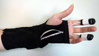
Upon registration at the museum entrance, visitors receive a special glove, which is equipped with biometric sensors and an active Ubisense tag. The exhibition is equipped with 20 Ubisense sensors that can locate the visitors positions with an accuracy of 15cm, as they move through the exhibition. In parallel the heart rate and electrical conductivity of the skin is measured and sent to the central server, which receives and analyses the results. At the end of the exhibition, visitors can view the results on a plasma screen showing their emotional excitement levels during the exhibition as well as other interesting data.
‘’We are delighted with the performance of the Ubisense tracking system’’, declares Roland Waespe, director of the Kunstmuseum St. Gallen. ‘’Our museum building presents a number of architectural challenges for radio based systems and we have been impressed with the reliability and precision of the system in this environment’’.
Research
Ubisense RFID tags transmitted the location data to Ubisense Series 7000 sensors, then forwarded that information to Ubisense’s Location Platform, that exported the captured data to other applications. The biometric data was transmitted via wireless LAN to MySQL database, where it was merged to location information. The location data was then used to determine which specific artworks the visitor had been viewing, how long that individual had looked at each piece. By comparing the biometric data, the researchers could measure a participant’s biological and cognitive reaction to each work of art.
It was found that more educated and elderly visitors had much more interest in classical works of art, whereas younger visitors, tended to be more stimulated by newer, more abstract works.
© Copyright Ubisense 2011

The institute for Art and Design and the University of Applied Science Northern Switzerland spent five weeks observing the reactions of visitors to a special exhibit at the Kunstmuseum St. Gallen. The goal was to obtain new insight into the emotional and cognitive reactions of visitors to the art objects.
Upon registration at the museum entrance, visitors receive a special glove, which is equipped with biometric sensors and an active Ubisense tag. The exhibition is equipped with 20 Ubisense sensors that can locate the visitors positions with an accuracy of 15cm, as they move through the exhibition. In parallel the heart rate and electrical conductivity of the skin is measured and sent to the central server, which receives and analyses the results. At the end of the exhibition, visitors can view the results on a plasma screen showing their emotional excitement levels during the exhibition as well as other interesting data.
 |
| A glove wearing visitor |
‘’We are delighted with the performance of the Ubisense tracking system’’, declares Roland Waespe, director of the Kunstmuseum St. Gallen. ‘’Our museum building presents a number of architectural challenges for radio based systems and we have been impressed with the reliability and precision of the system in this environment’’.
Research
Ubisense RFID tags transmitted the location data to Ubisense Series 7000 sensors, then forwarded that information to Ubisense’s Location Platform, that exported the captured data to other applications. The biometric data was transmitted via wireless LAN to MySQL database, where it was merged to location information. The location data was then used to determine which specific artworks the visitor had been viewing, how long that individual had looked at each piece. By comparing the biometric data, the researchers could measure a participant’s biological and cognitive reaction to each work of art.
It was found that more educated and elderly visitors had much more interest in classical works of art, whereas younger visitors, tended to be more stimulated by newer, more abstract works.
 |
| A computer screen displaying a visitor's tracks through the museum. The location data, merged with the bio-metric data, showed the visitors which artworks provoked cognitive or emotional responses. Each museum patron was then asked whether the recorded data matched his or her impression of how he or she responded. |
© Copyright Ubisense 2011
Thursday, September 08, 2011
Latest News
University of South Florida employs Ubisense's Real-time Location System to predict dementia from person's movement
Ubisense solution provides reliable, precise location accuracy to track the movement of people with cognitive decline and help to identify persons with dementia.
DENVER, Sept. 6, 2011 – A recent study conducted at the University of South Florida employed Ubisense’s real-time location system (RTLS) to track the movements of residents of two assisted living facilities (ALF). Using Ubisense’s solution and fractal mathematics, the researchers discovered that persons with dementia demonstrated more random movement in their walks and this random component was a better predictor of dementia than the Folstein Mini–Mental State Examination (MMSE), a primary tool used by clinicians to test for dementia.
Leading the study was Dr. William Kearns, an associate professor in the Department of Rehabilitation and Mental Health Counselling at the University of South Florida. Dr. Kearns and his team tracked the daytime movements of 25 elder ALF residents, 14 of whom had been diagnosed with dementia. The elders agreed to wear the Ubisense Compact Tags secured by a wristband and be monitored for 30 days during waking hours. Ubisense sensors were installed in the common use areas of the ALF.
The study’s primary aim was to examine the relationship of dementia to path tortuosity (the number of changes in direction of successive movement paths) and to movement speed and path length variability. Ubisense’s RTLS system tracked both changes in path direction and rate and duration of movement. The researchers found path tortuosity was greater in persons with dementia, and may be linked to impaired spatial memory required for successful navigation.
“We consider this to be a substantial finding and one that could potentially help us diagnose dementia earlier and enable us to provide better care for people demonstrating cognitive decline,” said Dr. Kearns.“Peoples’ behavior is the best indicator of what’s going on with them, and Ubisense’s RTLS system is the best solution we’ve found to provide the level of precise accuracy we need to validate our findings.”
Dr Kearns has been studying people with dementia for seven years in order to better understand the relationship of movement changes to future cognitive decline and fall risk. His goal is to discover ways to allow older persons to remain in their homes longer and to ease caregiver burden. More than 35 million people live with dementia worldwide. Over the next 40 years that number is projected to hit 115 million.[1]
Dr. Kearns first attempted to use an RFID-based system for his studies but found it produced inaccurate location data. A colleague in the USF College of Engineering suggested he consider ultra-wideband (UWB) technology for more precise accuracy, and Dr. Kearns sought help from Ubisense.
“This is great validation of our support for academic partners,” said Adrian Jennings, vice president of technology for Ubisense. “It’s people like Dr. Kearns who develop important new applications for our location solutions, applications which would be difficult to research outside of academia. We’re delighted to see the results of that openness, and proud to be a core element of Dr. Kearns’ important work.”
As a result of their valuable research, the United States Patent Office recently awarded a patent to Dr. Kearns and his colleagues for the “Human and Physical Asset Movement Pattern Analyzer,” which is an extension of their research using Ubisense’s RTLS. The Pattern Analyzer, based on UWB technology, helps identify changes in older individuals in ALFs. It is equally applicable to the study of traumatic brain injury in veterans.
For more information on Dr. Kearns’ research, see:
Kearns W.D., Fozard C.H., Nams V.O., Craighead J.D., Wireless telesurveillance system for detecting dementia, Gerontechnology 2011; 10(2):90-102; doi:10.4017/gt.2011.10.2.004.00 or see http://www.youtube.com/watch?v=lM89flOpwWQ
[1] http://www.alz.co.uk/research/statistics
Released: 6 September 2011
Photo: Ubisense In Action

Aston Martin has been benefiting from Ubisense's technology at its production line in Gaydon.
Photo: Bloomberg By Richard Tyler, Enterprise Editor
The 2011 FOSS4G Map by Jason Sanford
If you’re like me, at any given time you’ve got a number of new software products you’ve been hearing about, but just haven’t had time to tinker with. A few weeks back Peter Batty asked if I’d be interested in creating an interactive map for the upcoming FOSS4G conference that will be here in Denver. This sounded like the perfect opportunity to try out some new open source geo tools.
 I’ll start with a link to the map (http://2011.foss4g.org/content/foss4g-map) and tell you a little about how it works and what was used to create it. Visiting the site above displays a slippy map that you can pan and zoom like any other. The initial map shows four FOSS4G Venues as well as some light rail lines and stops to help you get around. As you zoom into the map you’ll see more information about bars, cafes, restaurants and even bicycle rental stations. Clicking these icons will show varying amounts of information in either a popup window or a small panel in the bottom left corner of the map.
All the pieces
The mapping library I’m using is Leaflet, from CloudMade. This is a great library that is very lightweight, easy to use, works great on mobile and most importantly, is open source. The core developer is very responsive to bugs and feature requests which is encouraging for those just getting started with Leaflet. If you haven’t checked out Leaflet yet or haven’t in the last few months, do yourself a favor and take a look. It’s grown by leaps and bounds lately and bugs are squashed often.
As I mentioned before the map shows various local amenities in the downtown Denver area. These come from OpenStreetMap and are periodically updated to keep the map fresh with updates from you. I’m sure you’ve all heard about OpenStreetMap. It’s awesome. End of story.
The OSM data is stored in PostGIS where we reference it for tile creation and map feature selection. PostGIS (/post’-jis/) is a spatial extension of the open source PostgreSQL database. PostGIS essentially adds spatial data types (geometry and geography) and lots (no really, hundreds) of functions to interact with these data types. If your data has a geometry question, PostGIS has one or more functions to answer it. PostGIS has installers for Windows and Mac and even has install packages for various linux flavors. It’s also not terribly hard to compile the source yourself. Even I’ve done this, once without cursing.
I’m creating map tiles with TileMill from Development Seed. TileMill is a browser based map design studio that can read from various data sources including shapefiles, KML, GeoJSON, PostGIS and GeoTIFF. With TileMill you create your map styles with Carto, a CSS-like map styling language that translates to Mapnik styles (correct me if I’m wrong) for super-fast tile rendering. Creating beautiful maps is so easy you’ll forget all about SLD. Recent updates include easy installation for both Mac OS X and Ubuntu (time to fire up the VMs windows users).
The product of a TileMill export is an mbtiles file which is an open spec for storing tiled map data in a SQLite database. This makes it much easier to transfer millions of map tiles to different locations as a single file, not the z/x/y.png directory hell that is the end result of most tiling jobs. I once vowed to quit map tiling efforts. Then I found TileMill. Anyway, we need a way to serve these tiles in this mbtiles format. Development Seed has another piece of open software for serving these, TileStream. You can download the source code for TileStream and build your own service or use a hosted solution for a fee and have your map tiles on a globally distributed CDN. Another solution, and the one I chose, is TileStache which python-based web application written by Michal Migurski that can serve and cache map tiles. With just a few lines of code you can tell TileStache where to find your mbtiles file, what URL to serve them from and where to cache the generated tiles.
Last but certainly not least is MapFish. MapFish is a Pylons (python) based application that lets you Create, Read, Update and Delete (CRUD) geographic features via HTTP POST, GET, PUT and DELETEs. For this application, I’ve extended MapFish to create a select service that simply runs multiple spatial queries against a few layers (bars, cafes, restaurants, bicycle rentals) with just one HTTP request. I’ve been using MapFish for a while now for a number of projects and highly recommend it.
Credit where credit is due
In addition to the projects above, there were a number of other resources used that deserve mention.
The OpenStreetMap data was downloaded from Geofabrik who graciously provide OSM data downloads to the state level updated daily. In my case it was very simple (and fast) to download just the data for Colorado. What an effort! Thanks Geofabrik.
The base map tiles come from MapQuest, who recently as part of their Open MapQuest efforts have released both street and aerial maps free for use, with pretty generous terms. Thanks MapQuest!
Speaking of OSM, our local Denver OSM Meetup Group have had a few recent efforts to help create a more accurate and complete map of downtown Denver. Thanks.
A note to local Denver folks: If you see a missing or incorrect bar, cafe, restaurant, etc in the map, update it in OpenStreetMap. I’ll be pulling fresh OSM data a time or two more before the conference.
About
 I’m Jason Sanford. I work for Ubisense building web mapping applications for electric/gas utilities and telcos. Over the last few years working with geospatial technology I’ve found that some of the best help I’ve received came from bloggers simply documenting their experiences, challenges and solutions. My goal here is to do the same.
Check out all of Jason's articles at http://geojason.info/

All the pieces
The mapping library I’m using is Leaflet, from CloudMade. This is a great library that is very lightweight, easy to use, works great on mobile and most importantly, is open source. The core developer is very responsive to bugs and feature requests which is encouraging for those just getting started with Leaflet. If you haven’t checked out Leaflet yet or haven’t in the last few months, do yourself a favor and take a look. It’s grown by leaps and bounds lately and bugs are squashed often.
As I mentioned before the map shows various local amenities in the downtown Denver area. These come from OpenStreetMap and are periodically updated to keep the map fresh with updates from you. I’m sure you’ve all heard about OpenStreetMap. It’s awesome. End of story.
The OSM data is stored in PostGIS where we reference it for tile creation and map feature selection. PostGIS (/post’-jis/) is a spatial extension of the open source PostgreSQL database. PostGIS essentially adds spatial data types (geometry and geography) and lots (no really, hundreds) of functions to interact with these data types. If your data has a geometry question, PostGIS has one or more functions to answer it. PostGIS has installers for Windows and Mac and even has install packages for various linux flavors. It’s also not terribly hard to compile the source yourself. Even I’ve done this, once without cursing.
I’m creating map tiles with TileMill from Development Seed. TileMill is a browser based map design studio that can read from various data sources including shapefiles, KML, GeoJSON, PostGIS and GeoTIFF. With TileMill you create your map styles with Carto, a CSS-like map styling language that translates to Mapnik styles (correct me if I’m wrong) for super-fast tile rendering. Creating beautiful maps is so easy you’ll forget all about SLD. Recent updates include easy installation for both Mac OS X and Ubuntu (time to fire up the VMs windows users).
The product of a TileMill export is an mbtiles file which is an open spec for storing tiled map data in a SQLite database. This makes it much easier to transfer millions of map tiles to different locations as a single file, not the z/x/y.png directory hell that is the end result of most tiling jobs. I once vowed to quit map tiling efforts. Then I found TileMill. Anyway, we need a way to serve these tiles in this mbtiles format. Development Seed has another piece of open software for serving these, TileStream. You can download the source code for TileStream and build your own service or use a hosted solution for a fee and have your map tiles on a globally distributed CDN. Another solution, and the one I chose, is TileStache which python-based web application written by Michal Migurski that can serve and cache map tiles. With just a few lines of code you can tell TileStache where to find your mbtiles file, what URL to serve them from and where to cache the generated tiles.
Last but certainly not least is MapFish. MapFish is a Pylons (python) based application that lets you Create, Read, Update and Delete (CRUD) geographic features via HTTP POST, GET, PUT and DELETEs. For this application, I’ve extended MapFish to create a select service that simply runs multiple spatial queries against a few layers (bars, cafes, restaurants, bicycle rentals) with just one HTTP request. I’ve been using MapFish for a while now for a number of projects and highly recommend it.
Credit where credit is due
In addition to the projects above, there were a number of other resources used that deserve mention.
The OpenStreetMap data was downloaded from Geofabrik who graciously provide OSM data downloads to the state level updated daily. In my case it was very simple (and fast) to download just the data for Colorado. What an effort! Thanks Geofabrik.
The base map tiles come from MapQuest, who recently as part of their Open MapQuest efforts have released both street and aerial maps free for use, with pretty generous terms. Thanks MapQuest!
Speaking of OSM, our local Denver OSM Meetup Group have had a few recent efforts to help create a more accurate and complete map of downtown Denver. Thanks.
A note to local Denver folks: If you see a missing or incorrect bar, cafe, restaurant, etc in the map, update it in OpenStreetMap. I’ll be pulling fresh OSM data a time or two more before the conference.
About
Check out all of Jason's articles at http://geojason.info/
Subscribe to:
Posts (Atom)